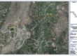

The Peshawar–Dera Ismail Khan motorway is a 360 km (220 mi) long proposed motorway connecting Peshawar with the southern parts of Khyber Pakhtunkhwa, Pakistan. Starting at the provincial capital Peshawar in the north, it will pass through Darra Adamkhel, Kohat, Hangu, Karak, Domel, Bannu, Lakki Marwat, and Darra Pezu, reaching Dera Ismail Khan at its southern end.
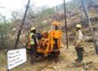
Stage: Feasibility Study & Detailed Design
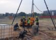
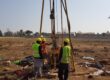
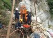
Number of Boreholes: 32 No’s
Diameter: HQ & NQ Standard Size with Triple Tube
Total Drilling: 875m
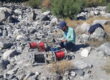
Mapping: Surface Geological Mapping, Engineering Geological Mapping, Scan line Survey
Electrical Resistivity Survey ERS: 72 No’s
Geotechnical Investigation & Geological Mapping: Geoengineers conducted drilling of 32 No. of boreholes with HQ & NQ Diameter with total drilling of upto 875m, ERS survey, surface geological mapping, engineering geological mapping and scan line survey.